Where? This was the big question in 2006. Where is it? Where am I? Where am I going? Where have I been? From being the stuff of government agencies, the military and big business, as well as navigators and explorers, the utilisation of geospatial data went mainstream. Millions of internet users were able to consult highly detailed satellite images of the world and became desktop explorers of an increasingly data rich mapping environment. At the same time the explosion of sales around the world in personal navigation devices (PNDs) employing global positioning system (GPS) receivers echoed the demand for geographical knowledge and data.
2006 saw increasing use of satellite imagery and geographical data in mainstream media and on home computers. This was largely due to mapping programmes like Google Earth (GE) and Google Maps, Microsoft’s Virtual Earth, (now integrated into Live Search) and Yahoo Maps. News programmes around the world incorporated new data visualisation tools into the reporting of stories in a variety of ways. Naturally enough the war in the Lebanon benefited from such coverage but so did the various outbreaks of bird flu around the globe and the progress of typhoons and hurricanes. The techniques were even used by sports programmes to illustrate the stadiums where matches were being played. Rather than employing traditional, static, two-dimensional cartography, these data visualisation tools allow the ‘zooming in’ on a predetermined spot and even the possibility of tilting the image giving the impression of relief.
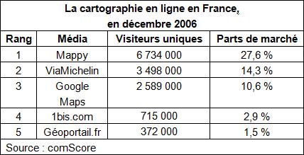
Sites which offer maps and itinerary planning are common on the Internet. In France Mappy reinforced its dominance of the French market but had some limited competition from a newcomer. With much hullabaloo, President Jacques Chirac officially launched the Géoportail website in June.[1] The site is the fruit of a joint development led by the Institut Géographique National (IGN) and the Bureau de Recherches Géologiques et Minières (BRGM). Such was the initial public interest, that the site was overwhelmed by 5 times the number of anticipated visitors. The underestimation resulted in two days of intermittent service and a frozen welcome page but with some additional resources, France, together with the French territories and overseas departments, were soon available in map and aerial or satellite photo formats. The site was generally well-received but comparisons with Google Earth were inevitable and the Géoportail interface still has long way to go to match the ease of use and fluidity of Google’s offer, and embarrassingly, sometimes the American satellite pictures are more detailed than the aerial photographs that the IGN provides.[2]; All the same we should not forget that France was a pioneer in the use of aerial photography in map-making, in the shape of Felix Nadar who was the first to take photographs from a tethered balloon in 1858 over Bièvres (Essonne).
The Géoportail is part of France’s contribution to the European Commission’s INSPIRE directive (Infrastructure for Spatial Information in the Community), one of whose key objectives is to “make more and better spatial data available for Community policy-making and implementation of Community policies in the Member States at all levels. INSPIRE focuses on environmental policy but is open for use by and future extension to other sectors such as agriculture, transport and energy.”[3]
The growing visibility of geospatial data is just the tip of the information iceberg that mapping programmes represent. No wonder then that the EC sees the potential benefits of sharing mapping and environmental data, Europe-wide. The EC would like the information to be freely available but some Member states were worried about the “financial sustainability” of offering, free of charge, expensively produced weather forecasting services. There has also been some concern expressed over public security, national defence, e-commerce, property rights and the right to privacy because mapping programmes, like the ones mentioned above, raise a great many issues, some of which, we will now examine.
Is Google Earth a threat to security?
The use of elaborate mapping technologies, which until now has been restricted to military or governmental agencies, has raised serious security concerns in some quarters. Already in October 2005 President Kalam of India regretted that sensitive areas like the Indian Army headquarters and Parliament buildings were clearly marked in Google Earth. Similar worries were heard in countries like South Korea, Thailand and the Netherlands. Australia demanded that images showing the Lucas Heights nuclear power station be removed. One step ahead of other countries, Israel has been protected under US Law from high resolution, US based, satellite imagery since the passing of a bill in 1997. Google’s policy however, is to incorporate higher resolution images as soon as they become available and not operate what is called ‘shutter control’- that is decided by the US government from whom much of the imagery comes, either directly, or indirectly through commercial agencies. Other trouble spots around the world are similarly doctored. Looking at South Korea’s border with North Korea some areas seem to be covered with snow on the South Korean side but on closer inspection, the imagery has clearly been altered. More bizarrely the Dutch Royal stables have also been subjected to ‘pixellisation’. Different web sites adopt different strategies. For example, on the French Géoportail site, President Chirac’s country retreat in the Corrèze region was masked by a large white spot![4]
We should not be surprised at these concerns. Google Earth’s origins lie in the purchase of the aptly named Keyhole Technologies in October 2004.[5] When challenged by critics, Google points out that the majority of satellite images used are already in the public domain, nor are they the only company that offers such images. Moreover, most of the satellite imagery is relatively old, two years seems to be about average, although in some regions like Dubai more recent images are available. Nor are the concerns related only to security; privacy issues were raised as images with greater resolutions offered increasing detail, allowing people’s shadows to be clearly distinguished along with houses, cars and swimming pools, speed cameras and nude sunbathers! The recently upgraded images of London however evoked criticism, not from Londoners worried about their privacy but from the tourist agencies of Liverpool and Manchester who complained that images of their cities were seriously out of date and needed replacing.
The increasing availability of geospatial data
One of the most interesting aspects of Google Earth in 2006 is not so much the images themselves but more the extraordinary way that information layers can now be superimposed upon them. For example SketchUp (software recently acquired by Google), a freely available 3D model and texturing programme, can be incorporated into Google Earth. The rather low-key launch of SketchUp belies its potential for integrating architectural features with the satellite images and maps. Three dimensional representations of well-known cities are now available and you can even hook up your game controller or flight simulator yoke to visit them. Another rich and colourful visual layer is afforded by Panoramio, a site that offers the possibility of uploading and displaying internet users’ photographs in their precise geo-reference. Panoramio is fully compatible with Google Earth. More practical perhaps is the possibility of seeing real-time traffic conditions but this is only available for the United States at the time of writing.
The incorporation of Global Positioning Systems data is now available in the pay versions of Google Earth (Google Earth Plus and Google Earth Pro) and while it is early days, the possibilities of being able to draw on the huge resources available in Google Earth will certainly result in many more GPS applications, some of which are already available in the free version.[6] The extension of mapping software is what distinguishes Google Earth from its rivals. There is the profusion of independent developers and amateur cartographers who are attracted to the field and whose talents are showcased in sites such as Google Earth Hacks, Google Earth Blog and Ogle Earth.[7]
An enormous amount of additional information can now be integrated to the visual representation found in Google Earth’s main screen. Not only are roads, relief, mountains and volcanoes labelled, but practical information like restaurants, chemists, automatic tellers, and supermarkets as well as houses for sale, crime statistics and the day’s weather can be superimposed or removed at will. Links to relevant articles in Wikipedia, the National Geographic magazine or architectural references are available, as are some institutional blogs. Outside links to other networks are also possible while at the same time viewing Google Earth content, allowing the tracking of airplane flights and weather systems. Another innovation allows the additional dimension of time to be factored into the mapping programme ; for example the advancement of urban development in London over the years and historical maps of Paris and London can be superimposed on the satellite images.
With its much improved interface and integrated layers, Google Earth is destined to become the educational and geo-referencing tool par excellence. Its exploitation in many other areas such as art, advertising, real-time geo-location, town planning and a multiplication of other uses will change the way we see and interact with our planet. ‘Mashups’, the aggregation of images, video, animation, text, together with map programmes like Google Earth, are becoming more common, particularly as learning tools. Some examples from 2006 follow :
– A Hurricane Katrina time animation.
– The spread of urbanisation in London.
– A 2006 US Election Guide, state by state, candidate by candidate.
– Spotlight on Africa, political and geographical data.
– Global Paleo-geographic animation showing continental drift.
– How a Ferris wheel works in Vienna.
– A collection of visible shipwrecks.
Monuments, natural wonders and historical sites are all being exploited for their educational potential. Google Earth is contributing significantly to the growing awareness of how big and how precious the world is. Environmental organisations like the United Nations Environment Programme have geo-referenced world trouble spots on Google Earth, allowing visitors to see problem areas for themselves, with before and after photographs and other statistical data. More radical environmental issues are visible at Sprol.com. The exact locations of endangered species are pin-pointed on Google Earth, illustrated by photographs together with information from the World Wildlife Fund, explaining what the issues are, and what is being done to conserve the threatened flora and fauna.
Nor does Google Earth stop at ground level; plans are underway for undersea mapping facilities to be incorporated into the programme. Google Moon has existed since 2005 and Google Mars since March 2006![8] In December 2006, Google also announced the Space Act Agreement with NASA Ames Research Center, to collaborate on large scale data management and human computer interfaces. Real-time weather maps and forecasting, space shuttle and space station tracking, as well as 3D mapping of the Moon and Mars, are all expected to become accessible in 2007, as a result of the collaboration.
Portable Navigation Device sales soar
The sales of portable global positioning devices (PND) reached record levels in 2006. Almost three million units were sold in the United States in 2006, an increase of 269 % on the previous year.[9] In France a million units were sold with a lively competitive market pushing down prices to less than € 200 in some cases.[10] These passive devices, (i.e. there is no connectivity between the satellites and the devices) have been around for some time, but what has made the difference are the improvements in the user interface. Colour LCD screens are now cheap and reliable. Memory is plentiful and economies of scale are aiding manufacturers to keep prices competitive. The devices themselves are manufactured by a number of companies, notably Magellan[11], Garmin, TomTom and newcomer Mio. Although top of the range goods and passenger vehicles are sold pre-equipped with GPS receivers, it was stand-alone devices that were extremely popular in 2006, largely at the expense of GPS embarked on personal digital assistants (PDAs) which suffered a significant sales downturn.
Until recently navigation devices were broadly divided into three categories: marine navigation, in-vehicle navigation for passenger and goods transport. and handheld devices for orienteering, trekking and other outdoor pursuits. Reductions in size have rendered handheld devices more versatile, being no longer restricted to use with one particular vehicle they are also small enough to be carried anywhere. They also became, as a result, targets for thieves! Car break-ins for PNDs became so prevalent in France in June 2006 that motorists were warned to hide their plastic PND supports, often visible on the dashboard, so that thieves would not be tempted to break into the car and search for the device.[12] To make matters worse, for the moment most PNDs are not equipped with security features like pin and chip protection, so resale is not a problem.
Developments in 2006 saw special PNDs for motor cycles and bicycles, while others are doubling as MP3 players with hard disk drives and voice activation controls. With FM radio connectivity, Traffic Message Channels (TMC) can be incorporated into the device providing real-time updates on traffic and road conditions. In some countries this information may be provided free of charge, but is more often available on a subscription basis. The software packages that provide map information and additional data are the keys to a successful PND product and they have become both rapid and sophisticated. Two companies dominate this side of the GPS market: Chicago based NavTech and the Dutch firm Tele Atlas. They provide information on changing road maps and the position of the all-important radar speed traps together with the integration of location based services (LBS) like service stations, car parks, restaurants and other Points of Interest (POI). We can see here the same proliferation of information layers as we observed in Google Maps and Google Earth. LBS services are becoming more and more important as GPS-aided navigation moves on from simple point to point directions, towards finding people, services and information, and with only some 10 % of European cars equipped with PNDs the future would appear to look very promising.
It should not be forgotten however, that a number of high-end mobile telephones now offer built-in GPS capability. So that the operators can generate revenue this means, for the moment at any rate, that the user must pay to make a request to the network if they wish to plan an itinerary or find POI information, which is a serious handicap to the development of GPS on mobiles. Nevertheless navigation services were certainly highest on the list of desirable features for American telephone users, according the 2005/2006 report of the National Technology Readiness Survey (NTRS), where 50 % of those surveyed expressed an interest in having access to such services.[13] It may be that the boom in PNDs will last only until telephone operators are willing to allow manufacturers to incorporate satellite receivers as a stand alone, value-added feature, and then be content to share revenues with the map information software providers. If such a time comes, the PNDs, so popular today, will quickly become obsolete.
Not just satellites
Navigational experts are now looking beyond simple satellite systems which, although very accurate outside, do not work underground or in enclosed spaces like buildings. What are called local positioning systems (LPS) and real-time location systems (RTLS), are techniques which make use of short-, medium- and wide-range radio networks such as 802.11 (Wi-Fi), Bluetooth, RFID, ultrasound, UWB, or TV and radio signals. Hybrid navigation and location methods will enable continuous tracking and positioning by switching from one technique to another, whenever necessary. Devices like this are already available in the shape of CATSeye, a covert system tracking device, smaller than a packet of cigarettes, which makes use of GPS, GSM and RF to pinpoint location both inside and outside. It is equipped with a movement sensor and a microphone.[14] A web-based interface enables the device to be tracked easily, with alerts given of any movement outside a predetermined area. Vehicle tracking is an obvious market but the device is small enough even to be incorporated into a PND, a fact that has allowed police forces in the United Kingdom to arrest PND thieves soon after they have committed a theft, tracing them through the very device they have stolen!
[2] To compare the different views see http://www.futura-sciences.com/comprendre/d/dossier653-1.php
[3] See http://www.europarl.europa.eu/news/expert/infopress_page/064-81-324-11-47-911-20061120IPR00064-20-11-2006-2006-false/default_en.htm
[4] Since M. Chirac will not be re-elected in 2007, we can expect to see the region in its entirety in June 2007. The Washington residence of Vice-President Dick Cheney is also obscured in Google Earth.
[5]Keyhole, en anglais, suggère une observation par le trou de la serrure !
[6] Compatibility with Garmin and Magellan PNDs
[8] See http://moon.google.com/ particularly at maximum resolution; and for an interesting Mars visit see http://www.google.com/mars/
[9] Source : Canalys estimates, http://www.canalys.com
[10] To obtain information about developments in GPS use in France, see http://news.navx.com/navx/
[11]Magellan Navigation, formerly Thales Navigation, was acquired in July 2006 by a group of investors led by Shah Capital Partners, a private equity firm based in Santa Clara, California.
[12] The police in les Yvelines, a French département launched an anti-theft campaign in August 2006.
[13] To send and receive email was only thought to be a desirable feature by 29%. For more details on the survey, see http://www.rhsmith.umd.edu/ces/pdfs_docs/NTRS-2005-06.pdf